The City of Tuscaloosa is located approximately 60 miles southwest of Birmingham. It lies on the fall line of the Black Warrior River approximately 193 miles upriver from the river's confluence with the Tombigbee River at Demopolis. Because of its location on the boundary between the Appalachian Highland and the Gulf Coastal Plain, the geography of the area around Tuscaloosa is diverse, varying from heavily forested hills to the northeast to a low-lying, marshy plain to the southwest.
The City of Tuscaloosa is affected by several natural events, but the most frequent are flooding and wind events, including hurricanes. Flash flooding results from rising creeks and rivers during a storm event and localized flooding due to storm events that exceed drainage system capacity or obstruct drainage systems. According to the National Oceanographic and Atmospheric Administration (NOAA), the normal rainfall for the City of Tuscaloosa is approximately 52.6 inches per year. This average rain fall amount is spread out over the course of a year and varies from event to event.
Flash flooding is dependent on the amount and duration of the rainfall as well as the condition of the watershed. High amounts of rain received over relatively short periods of time (usually hours) result in fast rising waters. The condition of the watershed also plays an important role in how local waterways react to storm events. Previously saturated areas or land covered by impervious materials, such as asphalt, will produce higher runoff rates, contributing a larger volume of water reaching the local waterways.
Floodplains serve a beneficial purpose to our quality of life. These low lying areas are where rainfall goes to drain and are adjacent to rivers and subject to flooding. Some examples of the major floodplains in the City limits of Tuscaloosa include Lake Tuscaloosa, the Black Warrior River, Cribbs Mill Creek, Cypress Creek, Cottondale Creek, Rum Creek and Moody Swamp.
Floodplains also serve as filters of stormwater runoff as it seeps through the ground. The natural vegetation filters out impurities and uses excess nutrients. It is important that we appreciate our floodplains, and try to maintain, preserve and restore these areas whenever possible. These benefits range from providing aesthetic pleasure to reducing the number and severity of floods, helping handle stormwater runoff and minimizing non-point source water pollution. Such natural processes cost far less money than it would take to build facilities to correct flood, stormwater, water quality and other community problems.
It is important to recognize that the floodplains serve many functions besides carrying or storing floodwaters. Thus, we should keep the water as clean as possible to help fish and other wildlife. Here are some things residents can do to protect the lakes, rivers and streams:
- Bag or compost all yard waste.
- Dispose of trash properly to decrease litter.
- Take used motor oil to a licensed recycling plant.
- Do not wash paints, thinners, anti-freeze, and other chemicals into the street. Take leftovers to a household hazardous waste collection center.
- Cover bare soil with a mulch and seed it as soon as possible to minimize erosion.
- Carefully apply lawn chemicals and limit the amount of fertilizers and pesticides being used.
- Keep as many green areas as possible as natural or man-made drainage swales. Plant plenty of trees and shrubs.

Floodplain
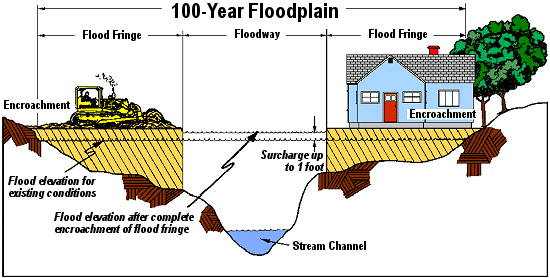
A floodplain is any land area susceptible to being inundated by water from any source. It includes the floodway and flood-fringe areas.
Flooding
An overflowing of water onto land that is normally dry. This can come from the overflow of inland waters, the unusual and rapid accumulation of stormwater runoff or of surface waters from any source.
Floodway
A floodway is the channel of a river or other watercourse and the adjacent land areas that must be reserved in order to discharge the base flood without cumulatively increasing the water surface elevation more than a designated height. The floodway is the most dangerous part of the floodplain. It is associated with moving water. Development is generally prohibited in floodways.
Flood-fringe
A flood-fringe is the portion of the floodplain outside of the floodway, which is covered by floodwater during the 100-year discharge. On a Flood Insurance Rate Map (FIRM), it is the Special Flood Hazard Area (SFHA) that's outside the floodway.
Base flood
A base flood means the flood having a one percent chance of being equaled or exceeded in any given year. It's also called the 1 percent chance flood or the 100-year flood.
Floodplain management
Floodplain management is the operation of an overall program of corrective and preventive measures for reducing flood damage, including but not limited to emergency preparedness plans, flood control works and floodplain management regulations.
Special Flood Hazard Area (SFHA)
This is floodplain land subject to a 1 percent chance, or greater, of flooding in any given year (see "Base flood" above). The area may be designated as "Zone A" on the flood hazard map. After detailed rate-making has been completed in preparation for the publication of a flood insurance rate map, Zone A usually is refined into Zones A, AO, AH, A1-30, AE, A99, AR, VO, or V1-30, VE or V.
Floodplain regulations:
- Protect life, health and property
- Minimize public flood control expenditures
- Minimize rescue and relief efforts
- Minimize business interruptions
- Minimize damage to public facilities
For more information, visit the Alabama Department of Economic and Community Affairs (ADECA) website: http://adeca.alabama.gov/Divisions/owr/floodplain/Pages/default.aspx
